What to see in Buenavista del Norte
Teno and the lighthouse

Here are the 33 places in Buenavista del Norte that we have on record, with how long each one takes, the bus that stops nearby and what to know before you go; and below, 7 places to eat. If you would rather have it all put together into one day, with lunch and the way back, that is what Naira does.
Let Naira plan your dayFor a swim
Playa de Las Arenas
beach · about 2 hours
Boulders / dark sand, 150 metres. Strong waves.
Warning: Classified as DANGEROUS in the official register of bathing areas. No assisted bathing.
Bus: stop URB. BUENAVISTA GREEN GOLF, 1.1 km away · line 369
Playa de El Fraile
beach · about 2 hours
Boulders / gravel / dark sand, 420 metres. Strong waves.
Facilities: parking
Warning: Classified as DANGEROUS in the official register of bathing areas. No assisted bathing.
Bus: stop CAMINO EL RISCO, 1.2 km away · line 369
Nature, trails and viewpoints
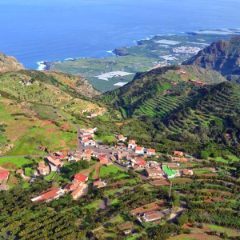
Los Bailaderos o Teno Alto
hamlet · an hour and a half
A stronghold of the island's rural customs, in the heart of the Teno Rural Park.
Bus: stop CAMINO EL RISCO, 2 km away · line 369
Autoguiado Circular Teno Alto
trail · about 50 min · good with kids
Official Cabildo trail: circular · 2.8 km · 91 m of climb · easy difficulty.
Bus: stop CAMINO EL RISCO, 2 km away · line 369
Las Portelas - Masca
trail · an hour and a half · good with kids
Official Cabildo trail: PR-TF 59 · linear · 3.7 km · 393 m of climb · moderate difficulty.
Bus: stop BIBLIOTECA - COLEGIO, 10 m away · lines 355, 365, 366
Callejón de Teno
trail · an hour and a half · good with kids
Official Cabildo trail: PR-TF 57 · linear · 3.9 km · 453 m of climb · hard difficulty.
Bus: stop LAS CANALES, 80 m away · lines 325, 355, 360, 365
Barranco de Masca
trail · about 3 hours
Official Cabildo trail: linear · 4.8 km · 939 m of climb · very hard difficulty.
Bus: stop MASCA (T), 20 m away · lines 355, 365
Mirador de Masca
viewpoint · about 25 min
From here you can see the hamlet tucked into the bottom of the ravine and, on a clear day, La Gomera opposite.
Getting there (in Spanish): Carretera de curvas cerradas
Bus: stop MASCA (T), 50 m away · lines 355, 365
Accesible Finca los Pedregales
trail · about 2 hours · good with kids
Official Cabildo trail: linear · 0 km · 3 m of climb · easy difficulty.
Bus: stop LAS CANALES, 590 m away · lines 325, 355, 360, 365
Autoguiado Circular Finca los Pedregales por las Casas de los Pedregales (Ruta 1)
trail · about 5 min · good with kids
Official Cabildo trail: circular · 0.2 km · 8 m of climb · easy difficulty.
Bus: stop LOS LLANITOS, 170 m away · lines 355, 365, 366
Autoguiado Circular Finca los Pedregales por el Área Recreativa (Ruta 2)
trail · about 20 min · good with kids
Official Cabildo trail: circular · 0.7 km · 57 m of climb · easy difficulty.
Bus: stop LAS CANALES, 590 m away · lines 325, 355, 360, 365
Los Carrizales
trail · an hour and a half · good with kids
Official Cabildo trail: PR-TF 51.1 · linear · 2.1 km · 518 m of climb · hard difficulty.
Bus: stop EL CARRIZAL (T), 1 km away · lines 355, 365
Circular de Bolico (Corta)
trail · about 55 min · good with kids
Official Cabildo trail: circular · 2.4 km · 183 m of climb · moderate difficulty.
Bus: stop LAS PORTELAS (T), 690 m away · lines 355, 365, 366
Monte del Agua. Ramal Las Lagunetas
trail · about 35 min · good with kids
Official Cabildo trail: PR-TF 52.2 · linear · 2.5 km · 12 m of climb · easy difficulty.
Bus: stop LAS LAGUNETAS, 600 m away · lines 355, 365, 366
Monte del Agua. Ramal Las Huertas
trail · about 55 min · good with kids
Official Cabildo trail: PR-TF 52.1 · linear · 2.9 km · 95 m of climb · easy difficulty.
Bus: stop LAS LAGUNETAS, 1.2 km away · lines 355, 365, 366
Circular de Bolico (Media)
trail · an hour and a half · good with kids
Official Cabildo trail: circular · 3.7 km · 294 m of climb · moderate difficulty.
Bus: stop LAS PORTELAS (T), 690 m away · lines 355, 365, 366
Camino del Risco
trail · about 2½ hours
Official Cabildo trail: PR-TF 58 · linear · 3.7 km · 844 m of climb · very hard difficulty.
Bus: stop CAMINO EL RISCO, 10 m away · line 369
Talavera
trail · about 2½ hours
Official Cabildo trail: PR-TF 55 · linear · 5.1 km · 702 m of climb · hard difficulty.
Bus: stop BENÍTEZ DE LUGO, 570 m away · lines 363, 372, 373
El Palmar - Casas de La Cumbre
trail · about 2½ hours
Official Cabildo trail: PR-TF 56 · linear · 5.6 km · 694 m of climb · hard difficulty.
Bus: stop EL PALMAR, 40 m away · lines 355, 365, 366
Circular de Bolico (Larga)
trail · about 3 hours
Official Cabildo trail: circular · 7.3 km · 592 m of climb · hard difficulty.
Bus: stop BIBLIOTECA - COLEGIO, 10 m away · lines 355, 365, 366
Circular El Palmar - Monte del Agua, por Las Lagunetas
trail · about 2½ hours
Official Cabildo trail: circular · 7.3 km · 463 m of climb · hard difficulty.
Bus: stop LAS CANALES, 100 m away · lines 325, 355, 360, 365
Mirador Altos de Baracán
viewpoint · about 25 min
This natural ridge divides the island into two such opposite climates that you can see the green forest soaked in mist on one side and the dry desert slope on the other.
Bus: stop LAS PORTELAS (T), 550 m away · lines 355, 365, 366
Mirador de Punta de Teno (y La Monja)
viewpoint · about 25 min · best at sunset
The Teno lighthouse at the north-western tip of the island, with the Los Gigantes cliffs in the background.
Getting there (in Spanish): Coches particulares, bicis y peatones no pueden pasar por la TF-445: se va en la guagua lanzadera desde Buenavista (10-19 h en invierno, 8-20 h en verano) o en taxi, y la carretera se cierra con mal tiempo.
Bus: stop PUNTA DE TENO, 280 m away · lines 369, 934, 935, 936
Mirador de La Cruz de Hilda (Morro de la Galera)
viewpoint · about 25 min · best at sunset
The hamlet of Masca and its crags, from La Fortaleza to the Llanos de Guergue; below there is a restaurant and an information panel.
Bus: stop CRUZ DE HILDA, 20 m away · lines 355, 365
The old town and its history
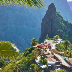
Caserío de Masca
old town · an hour and a half
Until the sixties there was no road to get here, so the villagers spent hours walking up the ravine to fetch basic supplies.
Bus: stop MASCA, 60 m away · line 355
Salinas de Buenavista del Norte
old town · an hour and a half
Small pools were dug into the bare rock to evaporate seawater and obtain salt, a resource so valuable it was used to pay the workers' wages.
Bus: stop SAN SEBASTIAN, 510 m away · lines 14, 26, 228, 232
Quesería Naturteno (Teno Alto)
cheese dairy · about 45 min
High up in Teno, one of the few places where traditional goat herding survives.
Getting there (in Spanish): Pista de tierra
Bus: stop ITOBAL, 2.7 km away · line 369
Quesería Flores de Teno
cheese dairy · about 45 min
A goat's cheese dairy in Teno Alto, where cheese is still made the way it always was.
Getting there (in Spanish): Carretera muy estrecha
Bus: stop ITOBAL, 1.2 km away · line 369
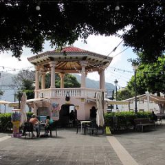
Buenavista del Norte
old town · an hour · good with kids
Declared a Bien de Interés Cultural in the Historic Ensemble category.
Bus: stop LA COOPERATIVA, 140 m away · lines 355, 365, 366
Photo: Joergsam · CC BY-SA 4.0 · Wikimedia Commons
Faro de Punta de Teno
lighthouse · an hour
It is the north-westernmost tip of Tenerife, a lighthouse built in 1897 with stone from La Gomera to guide ships along one of the most dangerous stretches of the ocean.
Bus: stop PUNTA DE TENO, 300 m away · lines 369, 934, 935, 936
Horno de Azabuche
heritage site · about 25 min · good with kids
A «craft installation» listed by the Cabildo.
Bus: stop CAMINO EL RISCO, 2.5 km away · line 369
Iglesia Las Portelas
church · about 30 min
Standing on the square of this Buenavista neighbourhood.
Bus: stop LAS PORTELAS (T), 300 m away · lines 355, 365, 366
Escultura Homenaje al Baile de las Libreas
sculpture · about 15 min
A bronze sculpture by the artist Eladio de la Cruz, paying tribute to the Libreas dance, a representative symbol of El Palmar's ethnographic treasure.
Bus: stop EL PALMAR, 70 m away · lines 355, 365, 366
Where to eat
Restaurante Mesón del Norte
grill · 12:00-17:00 · Friday also evening · Mon, Sat and Sun closed
Restaurante Casa Club
restaurant · Opening hours not confirmed · open every day
From the Cabildo register of premises: the address is Calle Vista La Monja sn. Opening hours not confirmed; call before you go.
Restaurante El Burgado
restaurant · Opening hours not confirmed · open every day
From the Cabildo register of premises: the address is Camino El Rincon 2. Opening hours not confirmed; call before you go.
And for an ice cream: Bar Heladeria el Castillo.
Getting there by bus
From Puerto de la Cruz
line 363, direct · an hour and a half · last bus back: 00:12 (Sat & Sun 00:02)
From La Orotava
line 363, direct · an hour · last bus back: 00:12 (Sat & Sun 00:02)
From Icod de los Vinos
line 363, direct · about 20 min · last bus back: 00:12 (Sat & Sun 00:02)
From San Cristóbal de La Laguna
lines 104 and 363, changing at La Orotava · about 2 hours
From Santa Cruz de Tenerife
lines 104 and 363, changing at La Orotava · about 2 hours
From Adeje
lines 343 and 363, changing at La Orotava · about 3½ hours
From Arona
lines 112, 104 and 363, changing at Santa Cruz de Tenerife and La Orotava · about 3½ hours
Weekday timetable, taken from the official TITSA timetable. Where you have to change buses we do not give the last one: a night-time journey back with changes is not one you can plan.
Let Naira plan your dayTell her what you fancy, where you are starting from and whether you have a car, and she builds the day with lunch and the way back.